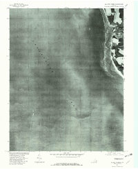
1977 Map of Elliotts Creek
USGS Topo · Published 1982About this map
Arlington occupies a prominent position on the Eastern Shore of Virginia in this 1970s orthophotoquad, which captures the immediate coastline where land meets the Chesapeake Bay. The map provides a photographic record of the landscape as it appeared in late 1977, showing the intricate network of tidal inlets including Elliotts Creek and Old Plantation Cr. The terrain is characterized by a high contrast between cultivated fields and dense coastal vegetation, illustrating the agricultural and maritime patterns of Northampton County. This aerial perspective, produced in cooperation with the Soil Conservation Service, offers a detailed view of drainage patterns and land use that traditional line-drawn topographic maps often generalize, making it a valuable resource for understanding the historical shoreline and property boundaries of this coastal region.
Find a feature on this map
4 named features on this map. Tap any name to fly to it.
Don’t see what you’re looking for? This feature index may not catch every label — zoom into the map to look around manually.
Map Details
Editions of this 1977 Elliotts Creek Map
This is the sole edition of this map. No revisions or reprints were ever made.
Other maps of this area

1942 · Cheriton
USGS Topo · 1:24,000

1943 · Elliots Creek
USGS Topo · 1:25,000

1943 · Townsend
USGS Topo · 1:24,000

1943 · Richmond
USGS Topo · 1:250,000

1946 · Eastville
USGS Topo · 1:250,000

1948 · Cape Charles
USGS Topo · 1:24,000

1949 · Richmond
USGS Topo · 1:250,000
1955 · Elliotts Creek
USGS Topo · 1:24,000
1955 · Cape Charles
USGS Topo · 1:24,000
1955 · Cheriton
USGS Topo · 1:24,000