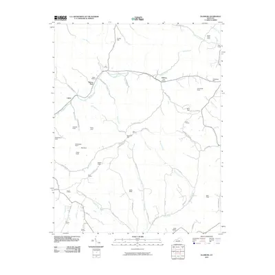
2010 Map of Ellisburg
USGS Topo · Published 2010About this map
Peytons Store and Ellisburg anchor this rural landscape in the southern Knobs region, where the Big South Fork of the Rolling Fork river system carves through narrow valleys. The terrain is defined by a dense network of high ridges and named peaks such as Chandler Knob, Rattlesnake Knob, and Turkeyfoot Knob. For genealogists, the map is particularly detailed, locating family-named cemeteries like Ellis Cemetery, Peyton Cemetery, and Smith Cemetery situated near old homesteads. The settlement pattern follows the drainage of Coffman Branch and Hill Branch, with historic routes like Coffman Branch Rd and Martin Creek Rd connecting these isolated communities. This survey provides a clear view of the topographic challenges and the traditional agricultural and timber-linked settlement layout of the area before modern land-use changes.
Find a feature on this map
73 named features on this map. Tap any name to fly to it.
Don’t see what you’re looking for? This feature index may not catch every label — zoom into the map to look around manually.
Map Details
Editions of this 2010 Ellisburg Map
This is the sole edition of this map. No revisions or reprints were ever made.
Other maps of this area

1905 · Harrodsburg
USGS Topo · 1:125,000

1952 · Ellisburg
USGS Topo · 1:24,000

1952 · Hustonville
USGS Topo · 1:24,000

1952 · Clementsville
USGS Topo · 1:24,000

1952 · Liberty
USGS Topo · 1:24,000

1952 · Yosemite
USGS Topo · 1:24,000

1952 · Junction City
USGS Topo · 1:24,000

1952 · Parksville
USGS Topo · 1:24,000

1953 · Bradfordsville NE
USGS Topo · 1:24,000

1953 · Gravel Switch
USGS Topo · 1:24,000