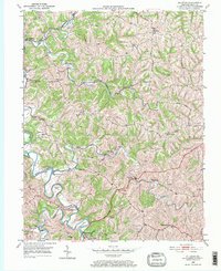
1950 Map of Elliston
USGS Topo · Published 1971About this map
Eagle Creek snakes through the tight valleys of northern Kentucky, defining the landscape around Elliston and Downingsville. This 1950 field check reveals a rural network of ridge-top roads and creek-bottom crossings, including the Eagle Mill Ford and a significant turn in the water at Horseshoe Bend. The northern reach of the map is punctuated by the Louisville and Nashville railroad, which follows the winding path of Ten Mile Creek past the community of Jericho. Local history is centered around country congregations like Vine Run Ch, Wesley Ch, and Mt Pisgah Ch, while family genealogists will find several small burial sites such as Webster Cem and Pruitt Cem. The road network, featuring the Warsaw Road and Baton Rouge Road, shows how these upland settlements remained connected despite the deeply dissected terrain of the Grant County area.
Find a feature on this map
35 named features on this map. Tap any name to fly to it.
Don’t see what you’re looking for? This feature index may not catch every label — zoom into the map to look around manually.
Map Details
Editions of this 1950 Elliston Map
2 editions found
Other maps of this area

1943 · Patriot
USGS Topo · 1:24,000

1950 · Mason
USGS Topo · 1:24,000

1950 · Glencoe
USGS Topo · 1:24,000

1950 · Elliston
USGS Topo · 1:24,000

1950 · Williamstown
USGS Topo · 1:24,000

1950 · Owenton
USGS Topo · 1:24,000

1950 · Verona
USGS Topo · 1:24,000

1950 · Walton
USGS Topo · 1:24,000

1950 · Lawrenceville
USGS Topo · 1:24,000
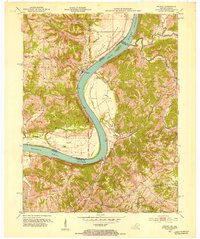
1951 · Patriot
USGS Topo · 1:24,000