
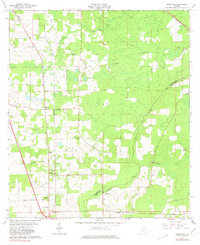
1963 Map of Ellisville
USGS Topo · Published 1964About this map
Olustee Creek and Swifts Creek meander through the wooded lowlands of north-central Florida, defining the boundary between Columbia Co and Union Co. This early 1960s landscape is characterized by a network of rural roads and scattered community centers that serve as anchors for local genealogy and history. Small settlements like Myrtis and Mason are joined by several family-named cemeteries and community churches, including Hopeful Ch, Mt Tabor Ch, and Old Providence Ch.
Find a feature on this map
26 named features on this map. Tap any name to fly to it.
Don’t see what you’re looking for? This feature index may not catch every label — zoom into the map to look around manually.
Map Details
Editions of this 1963 Ellisville Map
2 editions found
Other maps of this area

1954 · Gainesville
USGS Topo · 1:250,000

1954 · Valdosta
USGS Topo · 1:250,000

1958 · Valdosta
USGS Topo · 1:250,000

1958 · Gainesville
USGS Topo · 1:250,000

1959 · Valdosta
USGS Topo · 1:250,000

1959 · Gainesville
USGS Topo · 1:250,000

1962 · Lake City East
USGS Topo · 1:24,000

1962 · Mikesville
USGS Topo · 1:24,000

1963 · Olustee
USGS Topo · 1:24,000

1963 · Columbia
USGS Topo · 1:24,000