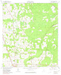
1963 Map of Ellisville
USGS Topo · Published 1980About this map
Ellisville and the surrounding rural landscape of northern Florida appear here during the early 1960s, a period defined by quiet agrarian settlements and a network of named country roads. This interior region is anchored by numerous community landmarks, including Everybodys Tabernacle, Bethlehem Ch, and Old Providence Ch. The map provides excellent genealogical detail through several family-named burial grounds like Farnell Cem, Hawthorne Cem, and Kerce Cem. To the east, the landscape transitions toward the Columbia and Union County line, marked by the winding paths of Olustee Creek and Swift Creek. Transportation is characterized by the Southern railway line in the northeast corner and a grid of local routes such as Lutheran Cross Road and Backnon Witt Road, which connect smaller locales like Myrtis and Mason to the larger crossroads at Ellisville.
Find a feature on this map
27 named features on this map. Tap any name to fly to it.
Don’t see what you’re looking for? This feature index may not catch every label — zoom into the map to look around manually.
Map Details
Editions of this 1963 Ellisville Map
2 editions found
Other maps of this area

1954 · Gainesville
USGS Topo · 1:250,000

1954 · Valdosta
USGS Topo · 1:250,000

1958 · Valdosta
USGS Topo · 1:250,000

1958 · Gainesville
USGS Topo · 1:250,000

1959 · Valdosta
USGS Topo · 1:250,000

1959 · Gainesville
USGS Topo · 1:250,000

1962 · Lake City East
USGS Topo · 1:24,000

1962 · Mikesville
USGS Topo · 1:24,000

1963 · Olustee
USGS Topo · 1:24,000

1963 · Ellisville
USGS Topo · 1:24,000