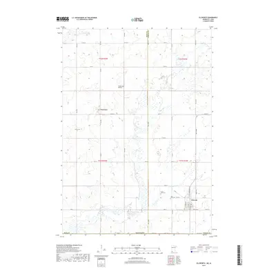
2019 Map of Ellsworth
USGS Topo · Published 2019About this map
Ellsworth anchors the southeast corner of this survey, situated on the prairie landscape just north of the Iowa state line. The town's grid, including N Broadway St and S Walnut St, is established near the confluence of Norwegian Cr and Kanaranzi Cr. The map captures a predominantly agricultural region defined by the geological rise of the Coteau des Prairies, an upland plateau that dictates the local drainage patterns. Moving northwest toward the small settlement of Kanaranzi, the landscape is dotted with several significant burial grounds, including Grand Prairie Cem and Ashwood Cem. These sites, along with Saint Mary's Cem, offer critical touchpoints for genealogists tracing families in this portion of Nobles and Rock Counties. The network of county roads like Co HWY 16 and Co HWY 15 illustrates the rectilinear division of the land typical of the Upper Midwest.
Find a feature on this map
46 named features on this map. Tap any name to fly to it.
Don’t see what you’re looking for? This feature index may not catch every label — zoom into the map to look around manually.
Map Details
Editions of this 2019 Ellsworth Map
This is the sole edition of this map. No revisions or reprints were ever made.
Other maps of this area

1954 · Fairmont
USGS Topo · 1:250,000

1955 · Sioux Falls
USGS Topo · 1:250,000

1958 · Sioux Falls
USGS Topo · 1:250,000

1958 · Fairmont
USGS Topo · 1:250,000

1967 · Magnolia
USGS Topo · 1:24,000

1967 · Adrian SW
USGS Topo · 1:24,000

1967 · Adrian
USGS Topo · 1:24,000

1967 · Ellsworth
USGS Topo · 1:24,000

1967 · Ash Creek
USGS Topo · 1:24,000
1967 · Luverne
USGS Topo · 1:24,000