
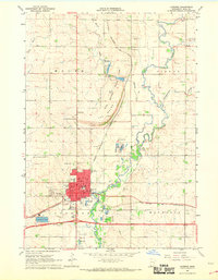
1967 Map of Ellsworth
USGS Topo · Published 1969About this map
Ellsworth serves as the primary hub in this late 1960s agricultural landscape, situated at the southern edge of Nobles County along the Minnesota-Iowa border. The town is a focal point for the Chicago Rock Island and Pacific railroad, which cuts diagonally across the prairie. The region's history is written in its cemeteries and infrastructure, from the small settlement of Kanaranzi to the Ashwood, Grand Prairie, and St Marys Cem burial grounds that serve the surrounding townships.
Find a feature on this map
20 named features on this map. Tap any name to fly to it.
Don’t see what you’re looking for? This feature index may not catch every label — zoom into the map to look around manually.
Map Details
Editions of this 1967 Ellsworth Map
This is the sole edition of this map. No revisions or reprints were ever made.
Other maps of this area

1954 · Fairmont
USGS Topo · 1:250,000

1955 · Sioux Falls
USGS Topo · 1:250,000

1958 · Sioux Falls
USGS Topo · 1:250,000

1958 · Fairmont
USGS Topo · 1:250,000

1967 · Magnolia
USGS Topo · 1:24,000

1967 · Adrian SW
USGS Topo · 1:24,000

1967 · Adrian
USGS Topo · 1:24,000

1967 · Ash Creek
USGS Topo · 1:24,000
1967 · Luverne
USGS Topo · 1:24,000

1971 · Edna
USGS Topo · 1:24,000