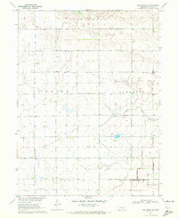
1970 Map of Elm Creek SE
USGS Topo · Published 1972About this map
The agricultural landscape of Phelps County is defined by a dense grid of rural sections and irrigation infrastructure as it appeared in the early 1970s. This survey of the Missouri River Basin development reveals the essential community anchors of a farming economy, including School No 5 and a local Townhall. Water management is central to the area's layout, with the meandering courses of North Dry Creek and Dry Creek contrasted against the engineered path of the BR 2319 Canal. Family and community history is preserved at the Magill Cemetery and the Emmaus Free Church, providing specific points of interest for genealogists tracing roots in the Cottonwood, Anderson, and Sheridan townships. Numerous wells dot the landscape, signaling the intensity of land use and the vital importance of groundwater in this Nebraska interior.
Find a feature on this map
17 named features on this map. Tap any name to fly to it.
Don’t see what you’re looking for? This feature index may not catch every label — zoom into the map to look around manually.
Map Details
Editions of this 1970 Elm Creek SE Map
This is the sole edition of this map. No revisions or reprints were ever made.
Other maps of this area

1894 · Kearney
USGS Topo · 1:62,500

1896 · Holdrege
USGS Topo · 1:125,000

1896 · Kearney
USGS Topo · 1:125,000

1955 · Grand Island
USGS Topo · 1:250,000

1957 · Grand Island
USGS Topo · 1:250,000

1958 · Grand Island
USGS Topo · 1:250,000

1961 · Elm Creek West
USGS Topo · 1:24,000

1962 · Elm Creek East
USGS Topo · 1:24,000
1962 · Alfalfa Center
USGS Topo · 1:24,000

1970 · Holdrege East
USGS Topo · 1:24,000