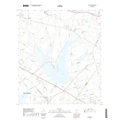
2019 Map of Elmendorf
USGS Topo · Published 2019About this map
Calaveras Lake dominates the central landscape of this 2019 survey, illustrating the managed water resources southeast of San Antonio. The map captures a detailed snapshot of the transition between the urban reach of San Antonio and the rural communities along the border of Bexar and Wilson counties. Smaller settlements like Elmendorf, China Grove, and Boldtville are documented alongside numerous family-named burial grounds including Arciniega Cem, Holbrecht Cem, and Sauceda Cem, providing a wealth of information for those researching local family ties. The infrastructure of the area is further defined by several reservoirs managed by the Soil Conservation Service, such as Site 5 and Site 8, while Cross-B Airport and Midlake Airport highlight the region's localized aviation history.
Find a feature on this map
98 named features on this map. Tap any name to fly to it.
Don’t see what you’re looking for? This feature index may not catch every label — zoom into the map to look around manually.
Map Details
Editions of this 2019 Elmendorf Map
This is the sole edition of this map. No revisions or reprints were ever made.
Other maps of this area
1936 · Floresville
USGS Topo · 1:62,500
1953 · San Antonio East
USGS Topo · 1:24,000
1953 · Elmendorf
USGS Topo · 1:24,000
1953 · Southton
USGS Topo · 1:24,000
1953 · Martinez
USGS Topo · 1:24,000

1954 · San Antonio
USGS Topo · 1:250,000
1957 · San Antonio
USGS Topo · 1:250,000
1958 · Losoya
USGS Topo · 1:24,000
1958 · La Vernia SW
USGS Topo · 1:24,000
1958 · Saspamco
USGS Topo · 1:24,000