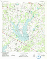
1992 Map of Elmendorf
USGS Topo · Published 1993About this map
Calaveras Lake dominates the center of this landscape southeast of San Antonio, serving as a cooling reservoir for the Sommers-Deely Power Plant. This industrial footprint is surrounded by a network of rural family histories, evidenced by the numerous small cemeteries such as Delgado Cem, Arciniega Cem, and Flores Cem that dot the countryside near Elmendorf. The map captures a moment of transition where traditional land use, represented by the Eckert Oil Field and old agricultural roads like Cassiano Road and Sulphur Springs Road, meets modern infrastructure.
Find a feature on this map
42 named features on this map. Tap any name to fly to it.
Don’t see what you’re looking for? This feature index may not catch every label — zoom into the map to look around manually.
Map Details
Editions of this 1992 Elmendorf Map
This is the sole edition of this map. No revisions or reprints were ever made.
Other maps of this area

1936 · Floresville
USGS Topo · 1:62,500

1953 · San Antonio East
USGS Topo · 1:24,000

1953 · Elmendorf
USGS Topo · 1:24,000

1953 · Southton
USGS Topo · 1:24,000

1953 · Martinez
USGS Topo · 1:24,000

1954 · San Antonio
USGS Topo · 1:250,000

1957 · San Antonio
USGS Topo · 1:250,000

1958 · Losoya
USGS Topo · 1:24,000

1958 · La Vernia SW
USGS Topo · 1:24,000

1958 · Saspamco
USGS Topo · 1:24,000