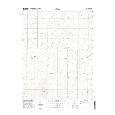
2015 Map of Elmo
USGS Topo · Published 2015About this map
Elmo and Dillon anchor this rural landscape in Dickinson County, defined by a meticulously surveyed grid of township roads and the winding paths of the Turkey Cr drainage system. The area is characterized by high ground between the various branches of the creek, including W Br Turkey Cr and E Turkey Cr. Genealogists will find significant value in the distribution of local burial grounds, such as Banner Cem near Elmo and Ashton Cem to the east. The presence of Mount Calvary Cem and the First Baptist Cem suggests the historical footprint of early community congregations. Aviation history is noted by the inclusion of Barnard Airport in the southern portion of the quadrangle, while the land remains primarily divided into the regular sections of townships t15s r2e and t15s r3e.
Find a feature on this map
31 named features on this map. Tap any name to fly to it.
Don’t see what you’re looking for? This feature index may not catch every label — zoom into the map to look around manually.
Map Details
Editions of this 2015 Elmo Map
This is the sole edition of this map. No revisions or reprints were ever made.
Other maps of this area
1889 · Abilene
USGS Topo · 1:125,000
1894 · Abilene
USGS Topo · 1:125,000
1955 · Hutchinson
USGS Topo · 1:250,000
1959 · Hutchinson
USGS Topo · 1:250,000
1963 · Abilene SW
USGS Topo · 1:24,000
1963 · Holland
USGS Topo · 1:24,000
1964 · Elmo
USGS Topo · 1:24,000
1964 · Carlton
USGS Topo · 1:24,000
1964 · Ramona
USGS Topo · 1:24,000
1964 · Navarre
USGS Topo · 1:24,000