
1964 Map of Elmo
USGS Topo · Published 1966About this map
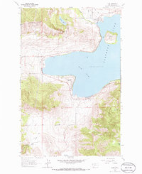
The western shores of Flathead Lake define this 1964 survey, centered on the deeply recessed Big Arm bay. This rugged landscape is dominated by the Hog Heaven Range in the northwest, which rises sharply above the lake to reach the prominent Chief Cliff. Settlement is concentrated in the small lakeside communities of Dayton, Elmo, and Big Arm, where the terrain transitions from steep mountains to more manageable shorelines.
Find a feature on this map
22 named features on this map. Tap any name to fly to it.
Don’t see what you’re looking for? This feature index may not catch every label — zoom into the map to look around manually.
Map Details
Editions of this 1964 Elmo Map
2 editions found
Other maps of this area

1920 · Flathead Lake
USGS Topo · 1:125,000

1956 · Wallace
USGS Topo · 1:250,000

1960 · Wallace
USGS Topo · 1:250,000

1964 · Buffalo Bridge
USGS Topo · 1:24,000

1964 · Wild Horse Island
USGS Topo · 1:24,000

1964 · Irvine Lookout Tower
USGS Topo · 1:24,000
1964 · Lake Mary Ronan
USGS Topo · 1:24,000
1964 · Rollins
USGS Topo · 1:24,000

1964 · Polson
USGS Topo · 1:24,000
1964 · Proctor
USGS Topo · 1:24,000