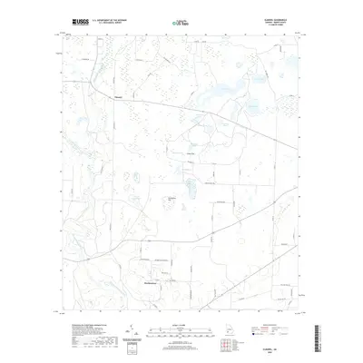
2020 Map of Elmodel
USGS Topo · Published 2020About this map
Hawkinstown and Elmodel anchor this Baker County landscape, where the hydrology of Southwest Georgia is on full display. The area is defined by the winding course of Ichawaynochaway Creek and its confluence with Chickasawhatchee Creek, creating a complex network of wetlands and namesake basins. The map reveals a specific cultural geography through its naming of numerous small water bodies, such as Baptizing Pond, Ginghouse Pond, and Bristol Pond.
Find a feature on this map
62 named features on this map. Tap any name to fly to it.
Don’t see what you’re looking for? This feature index may not catch every label — zoom into the map to look around manually.
Map Details
Editions of this 2020 Elmodel Map
This is the sole edition of this map. No revisions or reprints were ever made.
Other maps of this area

1953 · Dothan
USGS Topo · 1:250,000

1954 · Dothan
USGS Topo · 1:250,000

1955 · Dothan
USGS Topo · 1:250,000

1956 · Newton
USGS Topo · 1:62,500

1971 · Hopeful
USGS Topo · 1:24,000
1971 · Branchville
USGS Topo · 1:24,000

1974 · Cooktown
USGS Topo · 1:24,000

1974 · Elmodel
USGS Topo · 1:24,000
1974 · Newton
USGS Topo · 1:24,000
1974 · Leary
USGS Topo · 1:24,000