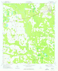
1974 Map of Leary
USGS Topo · Published 1976About this map
Ichawaynochaway Creek winds southward through this 1970s landscape, serving as a central geographic anchor for several small settlements and agricultural landmarks. The town of Leary stands in the northeast corner, connected to the smaller community of Williamsburg by the tracks of the Central of Georgia railroad. This rail corridor defines the northern movement of goods and people during this era, while the southern portion of the map is dominated by a network of creeks including Caney Creek, Mill Creek, and Pachitla Creek.
Find a feature on this map
22 named features on this map. Tap any name to fly to it.
Don’t see what you’re looking for? This feature index may not catch every label — zoom into the map to look around manually.
Map Details
Editions of this 1974 Leary Map
This is the sole edition of this map. No revisions or reprints were ever made.
Other maps of this area

1953 · Dothan
USGS Topo · 1:250,000

1954 · Dothan
USGS Topo · 1:250,000

1955 · Dothan
USGS Topo · 1:250,000

1956 · Newton
USGS Topo · 1:62,500

1956 · Sasser
USGS Topo · 1:62,500

1973 · Morgan
USGS Topo · 1:24,000
1973 · Holt
USGS Topo · 1:24,000

1973 · Edison
USGS Topo · 1:24,000

1974 · Damascus
USGS Topo · 1:24,000

1974 · Arlington
USGS Topo · 1:24,000