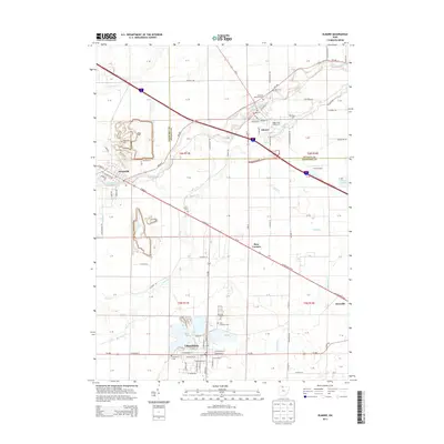
2013 Map of Elmore
USGS Topo · Published 2013About this map
Gibsonburg and Woodville anchor this northern Ohio landscape where the boundary between Sandusky and Ottawa counties meets the winding Portage River. The area is characterized by a high concentration of cemeteries, including Woodville Cem, Rice Cem, and Saint Lawrence Cem, which serve as vital markers for genealogical research in this region. The settlement pattern reflects a stable rural grid bisected by significant transportation corridors like US Highway 20 W and Oh-51.
Find a feature on this map
90 named features on this map. Tap any name to fly to it.
Don’t see what you’re looking for? This feature index may not catch every label — zoom into the map to look around manually.
Map Details
Editions of this 2013 Elmore Map
This is the sole edition of this map. No revisions or reprints were ever made.
Other maps of this area

1900 · Maumee Bay
USGS Topo · 1:62,500

1900 · Oak Harbor
USGS Topo · 1:62,500

1901 · Fremont
USGS Topo · 1:62,500

1901 · Elmore
USGS Topo · 1:62,500

1903 · Fremont
USGS Topo · 1:62,500

1903 · Elmore
USGS Topo · 1:62,500

1935 · Walbridge
USGS Topo · 1:24,000

1935 · Genoa
USGS Topo · 1:24,000

1938 · Walbridge
USGS Topo · 1:31,680
1938 · Genoa
USGS Topo · 1:31,680