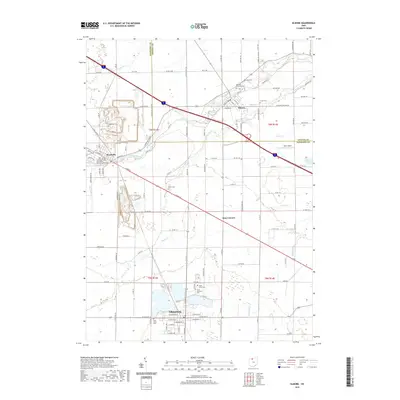
2019 Map of Elmore
USGS Topo · Published 2019About this map
The Portage River winds through the heart of this Sandusky and Ottawa County landscape, connecting the established communities of Woodville and Elmore. This modern survey illustrates a region defined by its agricultural layout and the drainage networks of Sugar Creek, Wolf Cr, and Toussaint Cr. While the town centers show dense residential grids along streets like W Main St and E Madison St, the surrounding area is characterized by large quarry operations and rural junctions such as Busy Corners. Aviation and recreation are noted by the presence of Haar Airport and Aldrich Pond, respectively. For genealogists and local historians, the map provides precise locations for the municipal development of Gibsonburg and the smaller hamlets that grew along the historic road and waterway corridors of northwest Ohio.
Find a feature on this map
103 named features on this map. Tap any name to fly to it.
Don’t see what you’re looking for? This feature index may not catch every label — zoom into the map to look around manually.
Map Details
Editions of this 2019 Elmore Map
This is the sole edition of this map. No revisions or reprints were ever made.
Other maps of this area

1900 · Maumee Bay
USGS Topo · 1:62,500

1900 · Oak Harbor
USGS Topo · 1:62,500

1901 · Fremont
USGS Topo · 1:62,500

1901 · Elmore
USGS Topo · 1:62,500

1903 · Fremont
USGS Topo · 1:62,500

1903 · Elmore
USGS Topo · 1:62,500

1935 · Walbridge
USGS Topo · 1:24,000

1935 · Genoa
USGS Topo · 1:24,000

1938 · Walbridge
USGS Topo · 1:31,680
1938 · Genoa
USGS Topo · 1:31,680