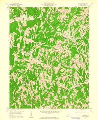
1958 Map of Elmwood
USGS Topo · Published 1960About this map
The boundary lines of Mason, Jackson, and Putnam counties intersect in this late 1950s survey of the West Virginia backcountry. The landscape is dominated by a dense network of high ridges, including Cain Ridge, Morrison Ridge, and Jim Ridge, which dictate the placement of small rural communities and transport routes. Elmwood serves as a central point of activity near the Mudlick Fork and Tribble Road, while the surrounding hollows are dotted with scattered family homesteads and small country schools such as New Jersey Sch and New Home Sch.
Find a feature on this map
55 named features on this map. Tap any name to fly to it.
Don’t see what you’re looking for? This feature index may not catch every label — zoom into the map to look around manually.
Map Details
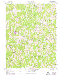
Editions of this 1958 Elmwood Map
2 editions found
Other maps of this area

1906 · Kenna
USGS Topo · 1:62,500

1906 · Winfield
USGS Topo · 1:62,500

1907 · Kenna
USGS Topo · 1:62,500

1907 · Ripley
USGS Topo · 1:62,500

1908 · Winfield
USGS Topo · 1:62,500

1908 · Ravenswood
USGS Topo · 1:62,500

1926 · Ravenswood
USGS Topo · 1:62,500

1926 · Ripley
USGS Topo · 1:62,500

1928 · Ravenswood
USGS Topo · 1:62,500

1928 · Ripley
USGS Topo · 1:62,500