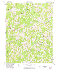
1958 Map of Elmwood
USGS Topo · Published 1976About this map
The settlement of Elmwood sits at a narrow junction of the Mudlick Fork and Sapsucker Run, illustrating the typical ridge-and-hollow settlement patterns of the West Virginia hills. In this 1958 survey, the landscape is defined by its social infrastructure of country churches and schoolhouses, such as Mount Zion Ch and New Jersey Sch, which are dispersed along the high ground of Jim Ridge and Cain Ridge. The intersection of multiple county lines, including Mason, Jackson, and Putnam, meet amidst a complex network of named drainages like Thirteenmile Creek and Eighteenmile Creek. These watercourses dictated the placement of small family cemeteries and local institutions like Walker Chapel, serving a rural population before the modern expansion of transportation networks.
Find a feature on this map
55 named features on this map. Tap any name to fly to it.
Don’t see what you’re looking for? This feature index may not catch every label — zoom into the map to look around manually.
Map Details
Editions of this 1958 Elmwood Map
2 editions found
Other maps of this area

1906 · Kenna
USGS Topo · 1:62,500

1906 · Winfield
USGS Topo · 1:62,500

1907 · Kenna
USGS Topo · 1:62,500

1907 · Ripley
USGS Topo · 1:62,500

1908 · Winfield
USGS Topo · 1:62,500

1908 · Ravenswood
USGS Topo · 1:62,500

1926 · Ravenswood
USGS Topo · 1:62,500

1926 · Ripley
USGS Topo · 1:62,500

1928 · Ravenswood
USGS Topo · 1:62,500

1928 · Ripley
USGS Topo · 1:62,500