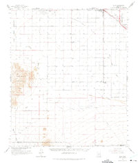
1963 Map of Eloy
USGS Topo · Published 1975About this map
The Santa Cruz Flats define the agricultural and industrial landscape of this Pinal County region during the early 1960s. The town of Eloy serves as a central hub, situated along the Southern Pacific railroad line near a Drive-in Theater and local substations. The landscape is a network of irrigation and water management, evidenced by the Santa Cruz River, Greene Canal, and numerous roads named for local families, such as Alsdorf Road, Pretzer Road, and Baumgartner Road. To the west, the Sawtooth Mountains rise sharply from the valley floor, marked by various prospects and the edge of the Papago Indian Reservation. The map captures a period of desert development, showing the early layout of Arizona City and outlying locales like Friendly Corners and Curry Camp amidst a grid of section lines and wells.
Find a feature on this map
36 named features on this map. Tap any name to fly to it.
Don’t see what you’re looking for? This feature index may not catch every label — zoom into the map to look around manually.
Map Details
Editions of this 1963 Eloy Map
2 editions found
Other maps of this area

1922 · Red Rock No 2
USGS Topo · 1:48,000

1922 · Casa Grande
USGS Topo · 1:62,500

1922 · Signal Peak
USGS Topo · 1:62,500

1924 · Signal Peak
USGS Topo · 1:62,500

1924 · Casa Grande
USGS Topo · 1:62,500

1934 · Tucson Mountains
USGS Topo · 1:125,000

1934 · Silver Bell
USGS Topo · 1:125,000

1934 · Newman Peak
USGS Topo · 1:125,000

1942 · Silver Reef Mountains
USGS Topo · 1:62,500

1947 · Red Rock
USGS Topo · 1:62,500