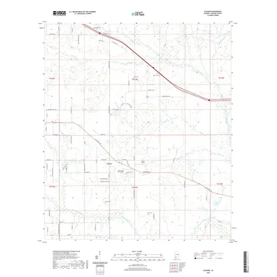
2020 Map of Elsanor
USGS Topo · Published 2020About this map
Elsanor serves as the central hub of this Baldwin County landscape, situated at the junction of modern transit and historical routes. The map illustrates a coastal plain geography defined by the winding course of the Styx River and the Blackwater River, which shape the drainage patterns of numerous local tributaries like Cowpen Creek and Buckhorn Br. The local economy and land use are reflected in specialized aviation sites such as the Elsanor Airport and the Pecan Ponds Farm Airport, as well as the naming of many rural roads after local families. Genealogists will find interest in the Oak Grove Cem and Greek Cem, while those studying historical transportation can trace the alignment of the Old Spanish Trl as it cuts across the township divisions toward Pace Lake and the river basins.
Find a feature on this map
74 named features on this map. Tap any name to fly to it.
Don’t see what you’re looking for? This feature index may not catch every label — zoom into the map to look around manually.
Map Details
Editions of this 2020 Elsanor Map
This is the sole edition of this map. No revisions or reprints were ever made.
Other maps of this area

1920 · Robertsdale
USGS Topo · 1:62,500

1921 · Bon Secour
USGS Topo · 1:62,500

1921 · Fort Barrancas
USGS Topo · 1:62,500

1921 · Muscogee
USGS Topo · 1:62,500

1941 · Fort Barrancas
USGS Topo · 1:62,500

1941 · Muscogee
USGS Topo · 1:62,500

1941 · Robertsdale
USGS Topo · 1:62,500

1941 · Foley
USGS Topo · 1:62,500

1943 · Robertsdale
USGS Topo · 1:62,500

1943 · Muscogee
USGS Topo · 1:62,500