
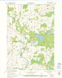
1969 Map of Embarrass
USGS Topo · Published 1971About this map
The Embarrass River meanders across this landscape, defining the boundary between Belle Plaine and Matteson as it flows toward the south. This late-1960s survey records a rural landscape anchored by the village of Embarrass, where a concentrated settlement is supported by municipal infrastructure like a Water Tank and Sewage Disposal system. Further north, the lake country comes into view, centered on the recreational clusters at Adams Beach and the interconnected waters of Pine Lake, Grass Lake, and Round Lake.
Find a feature on this map
41 named features on this map. Tap any name to fly to it.
Don’t see what you’re looking for? This feature index may not catch every label — zoom into the map to look around manually.
Map Details
Editions of this 1969 Embarrass Map
2 editions found
Other maps of this area

1954 · Gresham
USGS Topo · 1:48,000

1954 · Shawano
USGS Topo · 1:48,000

1955 · Embarrass
USGS Topo · 1:48,000

1955 · Clintonville
USGS Topo · 1:48,000

1955 · Green Bay
USGS Topo · 1:250,000

1964 · Shawano
USGS Topo · 1:62,500

1964 · Gresham
USGS Topo · 1:62,500

1969 · Leeman
USGS Topo · 1:24,000

1969 · Lunds
USGS Topo · 1:24,000

1969 · Bear Creek
USGS Topo · 1:24,000