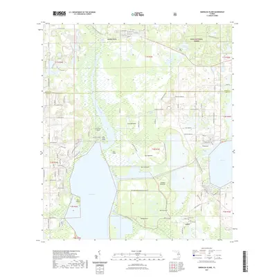
2021 Map of Emeralda Island
USGS Topo · Published 2021About this map
The Ocklawaha River winds through the northern reaches of this landscape, marking a watery boundary near Starkes Ferry before it enters the expansive Emeralda Marsh. This area, situated between the large basins of Lake Griffin and Lake Yale, is characterized by a complex network of wetlands and "hammocks"—islands of higher ground such as Bull Hammock, Cabbage Hammock, and the extensive Big Hammock to the south. The small settlement of Lisbon sits near the southeastern corner, serving as a focal point for local history with its nearby Lisbon Cem. Much of the northern terrain is preserved within the Ocala National Forest, where trails like the Prairie Riding Loop Trl provide access to the interior. The map illustrates a delicate balance between the conserved marshlands and the residential development encroaching from the west near Gator Lake.
Find a feature on this map
109 named features on this map. Tap any name to fly to it.
Don’t see what you’re looking for? This feature index may not catch every label — zoom into the map to look around manually.
Map Details
Editions of this 2021 Emeralda Island Map
This is the sole edition of this map. No revisions or reprints were ever made.
Other maps of this area

1954 · Daytona Beach
USGS Topo · 1:250,000

1955 · Orlando
USGS Topo · 1:250,000

1957 · Orlando
USGS Topo · 1:250,000

1958 · Orlando
USGS Topo · 1:250,000

1958 · Daytona Beach
USGS Topo · 1:250,000

1962 · Orlando
USGS Topo · 1:250,000

1964 · Daytona Beach
USGS Topo · 1:250,000

1965 · Leesburg East
USGS Topo · 1:24,000

1965 · Umatilla
USGS Topo · 1:24,000

1966 · Leesburg West
USGS Topo · 1:24,000