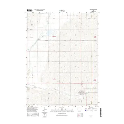
2015 Map of Emerson
USGS Topo · Published 2015About this map
The West Nishnabotna River cuts through the western portion of this Mills County landscape, anchored by the town of Hastings. In the southeastern corner, the community of Emerson sits at the confluence of several rural routes and Indian Creek. The terrain is defined by its agricultural grid, where small family landmarks and rural burials provide deep genealogical value. Local history is preserved in sites like the Saylor Farm Cem and North Grove Cem, which dot the uplands between the river valley and the smaller tributaries of Douglas Creek and Mud Creek. Infrastructure of the era is represented by the Nishnabotna River Bridge and the rail-aligned streets of S Railway St, illustrating the enduring intersection of water, rail, and road in this Iowa farming region.
Find a feature on this map
42 named features on this map. Tap any name to fly to it.
Don’t see what you’re looking for? This feature index may not catch every label — zoom into the map to look around manually.
Map Details
Editions of this 2015 Emerson Map
This is the sole edition of this map. No revisions or reprints were ever made.
Other maps of this area

1954 · Omaha
USGS Topo · 1:250,000
1955 · Nebraska City
USGS Topo · 1:250,000
1956 · Treynor
USGS Topo · 1:24,000
1956 · Malvern
USGS Topo · 1:24,000
1957 · Nebraska City
USGS Topo · 1:250,000

1957 · Omaha
USGS Topo · 1:250,000
1957 · Tabor NE
USGS Topo · 1:24,000

1958 · Omaha
USGS Topo · 1:250,000
1958 · Nebraska City
USGS Topo · 1:250,000
1978 · Carson
USGS Topo · 1:24,000