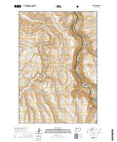
2020 Map of Emerson
USGS Topo · Published 2020About this map
The settlement of Emerson and the surrounding canyonlands of Wasco County are defined by the winding course of the Deschutes Wild and Scenic River. This high-desert landscape in the shadow of the Mount Hood National Forest shows a transition between agricultural plateaus and deep river gorges. Local water sources such as Ferry Springs and Kelly Spring provided essential relief in this arid environment, while drainage systems like Fifteenmile Cr and Davis Cr carved out prominent features including Standard Hollow and Douglas Hollow. The map detail reveals a network of rural roads such as Columbia Hall Rd and Kloan Rd that connect isolated ridges like Fulton Ridge to the river's edge, where the Deschutes River Trail follows the water through Ferry Springs Canyon and past Gordon Butte.
Find a feature on this map
43 named features on this map. Tap any name to fly to it.
Don’t see what you’re looking for? This feature index may not catch every label — zoom into the map to look around manually.
Map Details
Editions of this 2020 Emerson Map
This is the sole edition of this map. No revisions or reprints were ever made.
Other maps of this area

1930 · Dufur
USGS Topo · 1:125,000

1934 · Dufur
USGS Topo · 1:125,000

1934 · The Dalles
USGS Topo · 1:125,000

1953 · The Dalles
USGS Topo · 1:250,000

1956 · The Dalles
USGS Topo · 1:250,000

1957 · The Dalles
USGS Topo · 1:250,000

1957 · The Dalles
USGS Topo · 1:62,500

1957 · Wishram
USGS Topo · 1:62,500

1962 · Erskine
USGS Topo · 1:24,000

1962 · Summit Ridge
USGS Topo · 1:24,000