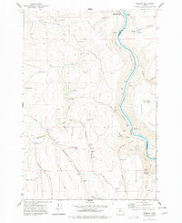
1977 Map of Emerson
USGS Topo · Published 1977About this map
The Deschutes River carves a deep canyon through this high-desert landscape, serving as the boundary between Wasco and Sherman Counties. Along its banks, the Burlington Northern railroad follows the water's edge, passing through small rail-side locations like Kloan and Pollywog. An intriguing glimpse into the area's development is provided by the Old RR Grade and the Free Bridge Historical Site near Ferry Springs.
Find a feature on this map
45 named features on this map. Tap any name to fly to it.
Don’t see what you’re looking for? This feature index may not catch every label — zoom into the map to look around manually.
Map Details
Editions of this 1977 Emerson Map
This is the sole edition of this map. No revisions or reprints were ever made.
Other maps of this area

1930 · Dufur
USGS Topo · 1:125,000

1934 · Dufur
USGS Topo · 1:125,000

1934 · The Dalles
USGS Topo · 1:125,000

1953 · The Dalles
USGS Topo · 1:250,000

1956 · The Dalles
USGS Topo · 1:250,000

1957 · The Dalles
USGS Topo · 1:250,000

1957 · The Dalles
USGS Topo · 1:62,500

1957 · Wishram
USGS Topo · 1:62,500

1962 · Erskine
USGS Topo · 1:24,000

1962 · Summit Ridge
USGS Topo · 1:24,000