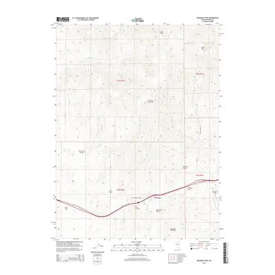
2014 Map of Emigrant Pass
USGS Topo · Published 2014About this map
Emigrant Pass and the surrounding Tuscarora Mountains anchor this high-desert landscape in northern Nevada. The terrain is defined by a series of significant drainage systems and peaks, including Carlin Peaks and Marys Mtn. Settlement is sparse, centered on the small siding of Primeaux and the open expanse of Bobs Flat. The map reveals a complex network of seasonal water sources and springs such as Emigrant Spring, Fish Pond Spring, and Fuzzy Spring, which have historically been critical for transit through this arid corridor. Transportation follows the natural contours of the land, moving through Emigrant Canyon and over Twin Summit. Significant geological features like Stone Wall Canyon and Bob Creek Canyon illustrate the erosive forces shaping the region's topography, providing a detailed look at the land's character near the Eureka and Elko county lines.
Find a feature on this map
28 named features on this map. Tap any name to fly to it.
Don’t see what you’re looking for? This feature index may not catch every label — zoom into the map to look around manually.
Map Details
Editions of this 2014 Emigrant Pass Map
This is the sole edition of this map. No revisions or reprints were ever made.
Other maps of this area

1952 · Carlin
USGS Topo · 1:62,500

1955 · Winnemucca
USGS Topo · 1:250,000

1957 · Beowawe
USGS Topo · 1:62,500

1958 · Winnemucca
USGS Topo · 1:250,000

1962 · Winnemucca
USGS Topo · 1:250,000

1968 · Rodeo Creek SW
USGS Topo · 1:24,000

1968 · Welches Canyon
USGS Topo · 1:24,000
1968 · Schroeder Mtn
USGS Topo · 1:24,000

1985 · Scotts Gulch
USGS Topo · 1:24,000
1985 · Palisade
USGS Topo · 1:24,000