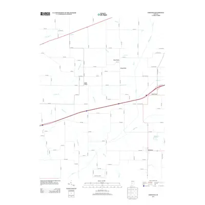
2013 Map of Eminence
USGS Topo · Published 2013About this map
Eminence and Belle Union anchor this survey of the Central Indiana countryside, where the landscape is defined by a dense network of county roads and meandering drainage systems. This 2013 map captures a distinct agricultural and residential pattern, showing the transition from established small settlements to rural developments like Lazy Acres Est and the cluster of Board Park and Broad Park. The hydrology of the area is particularly detailed, tracing the courses of Cotton Br, Belle Union Br, and Vermillion Br, alongside man-made improvements such as Lake Ditch and Mill Cr Ditch. For those researching local aviation or private landmarks, the inclusion of Pam's Place Airport in the south provides a unique point of interest. The map also records the presence of Whispering Wind Lake, a prominent water feature situated near the crossroads of Eminence.
Find a feature on this map
75 named features on this map. Tap any name to fly to it.
Don’t see what you’re looking for? This feature index may not catch every label — zoom into the map to look around manually.
Map Details
Editions of this 2013 Eminence Map
This is the sole edition of this map. No revisions or reprints were ever made.
Other maps of this area

1949 · Quincy
USGS Topo · 1:24,000

1953 · Clayton
USGS Topo · 1:24,000

1953 · Indianapolis
USGS Topo · 1:250,000

1955 · Hall
USGS Topo · 1:24,000

1956 · Indianapolis
USGS Topo · 1:250,000

1956 · Cloverdale
USGS Topo · 1:24,000

1956 · Cataract
USGS Topo · 1:24,000

1956 · Eminence
USGS Topo · 1:24,000

1957 · Indianapolis
USGS Topo · 1:250,000
1957 · Paragon
USGS Topo · 1:24,000