
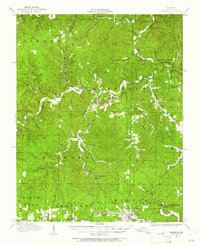
1915 Map of Eminence
USGS Topo · Published 1956About this map
Eminence and West Eminence serve as the central hubs for this 1915 survey of the Ozark landscape, where the confluence of the Current River and Jacks Fork dictates the region's geography. The map captures a transition in Shannon County as timber and rail operations shaped local life. In the southern reach, the St Louis and San Francisco RR connects the towns of Winona and Bartlett, while the Clark National Forest begins to define the surrounding timberlands. Numerous country schools, such as Bee Bluff School, Munsell School, and Flatwoods School, are scattered through the hollows, marking the dispersed community structure of the era. Water sources are critical to the survey, highlighting unique features like Ebb and Flow Springs and Buckheart Springs. The map also preserves the location of the Angeline P.O. and early settlements like Delaware, providing a detailed look at the rural infrastructure before modern road networks dominated the terrain.
Find a feature on this map
60 named features on this map. Tap any name to fly to it.
Don’t see what you’re looking for? This feature index may not catch every label — zoom into the map to look around manually.
Map Details
Editions of this 1915 Eminence Map
2 editions found
Other maps of this area

1917 · Eminence
USGS Topo · 1:62,500

1928 · Cardareva
USGS Topo · 1:62,500

1931 · Bandyville
USGS Topo · 1:48,000

1932 · Cedar Grove
USGS Topo · 1:48,000

1944 · Van Buren
USGS Topo · 1:62,500

1944 · Birch Tree
USGS Topo · 1:62,500

1944 · Corridon
USGS Topo · 1:62,500

1945 · Montier
USGS Topo · 1:62,500

1945 · Round Spring
USGS Topo · 1:62,500

1946 · Summersville
USGS Topo · 1:62,500