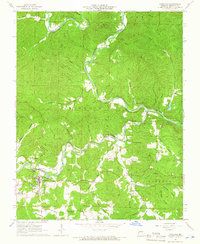
1965 Map of Eminence
USGS Topo · Published 1966About this map
The Current River and Jacks Fork converge in this mid-1960s survey of Shannon County, revealing a landscape defined by deep river valleys and high overlooks. The settlement of Eminence serves as the focal point, with its residential area and services like the Sewage Disposal Pond and Gaging Station clustered near the water's edge. To the west, West Eminence sits along the foothills near Storys Creek.
Find a feature on this map
52 named features on this map. Tap any name to fly to it.
Don’t see what you’re looking for? This feature index may not catch every label — zoom into the map to look around manually.
Map Details
Editions of this 1965 Eminence Map
4 editions found
Other maps of this area

1915 · Eminence
USGS Topo · 1:62,500

1917 · Eminence
USGS Topo · 1:62,500

1928 · Cardareva
USGS Topo · 1:62,500

1944 · Corridon
USGS Topo · 1:62,500

1945 · Round Spring
USGS Topo · 1:62,500

1947 · Sinkin
USGS Topo · 1:48,000

1947 · Corridon
USGS Topo · 1:62,500

1949 · Round Spring
USGS Topo · 1:62,500

1949 · Rolla
USGS Topo · 1:250,000

1949 · Cardareva
USGS Topo · 1:62,500