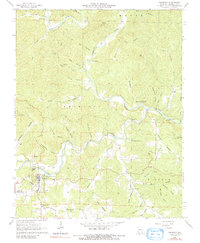
1965 Map of Eminence
USGS Topo · Published 1991About this map
Eminence and West Eminence serve as the primary hubs in this mid-1960s Ozark landscape, positioned at the convergence of the Current River and Jacks Fork. The terrain is defined by a dense network of hollows, such as Coppermine Hollow and Lick Log Hollow, which give way to prominent elevations like Jerktail Mountain and Tip Top Mtn. The map reveals a community deeply connected to its river-bottom land and rugged hills, evidenced by numerous family and community burial grounds including Chilton Cem and Lower Grassy Cem.
Find a feature on this map
59 named features on this map. Tap any name to fly to it.
Don’t see what you’re looking for? This feature index may not catch every label — zoom into the map to look around manually.
Map Details
Editions of this 1965 Eminence Map
4 editions found
Other maps of this area

1915 · Eminence
USGS Topo · 1:62,500

1917 · Eminence
USGS Topo · 1:62,500

1928 · Cardareva
USGS Topo · 1:62,500

1944 · Corridon
USGS Topo · 1:62,500

1945 · Round Spring
USGS Topo · 1:62,500

1947 · Sinkin
USGS Topo · 1:48,000

1947 · Corridon
USGS Topo · 1:62,500

1949 · Round Spring
USGS Topo · 1:62,500

1949 · Rolla
USGS Topo · 1:250,000

1949 · Cardareva
USGS Topo · 1:62,500