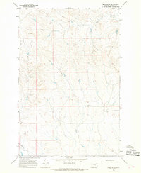
1965 Map of Emma Butte
USGS Topo · Published 1968About this map
Emma Butte stands as a prominent landmark in this mid-1960s landscape, presiding over the dry drainage patterns of central Garfield County. The map reveals a sparse, high-plains settlement pattern characterized by scattered wells and expansive sections, where water sources like Sand Creek and Indian Creek dictate the layout of the land. A significant cultural anchor is found at the Indian Creek Sch, a local schoolhouse serving the ranching families that occupied this stretch of the Montana prairie. Along the western edge, the terrain transitions toward McGinnis and McGinnis Creek, while Piney Ridge provides a distinct topographic boundary to the east. This survey captures a moment in time when rural educational centers and specific water improvements were the primary indicators of human presence in this remote grazing country.
Find a feature on this map
11 named features on this map. Tap any name to fly to it.
Don’t see what you’re looking for? This feature index may not catch every label — zoom into the map to look around manually.
Map Details
Editions of this 1965 Emma Butte Map
This is the sole edition of this map. No revisions or reprints were ever made.
Other maps of this area

1954 · Jordan
USGS Topo · 1:250,000

1954 · Forsyth
USGS Topo · 1:250,000

1956 · Jordan
USGS Topo · 1:250,000

1957 · Forsyth
USGS Topo · 1:250,000

1958 · Jordan
USGS Topo · 1:250,000

1958 · Forsyth
USGS Topo · 1:250,000

1964 · Jordan
USGS Topo · 1:250,000

1965 · Robertson School
USGS Topo · 1:24,000
1965 · Sand Springs
USGS Topo · 1:24,000

1965 · Hole-In-The-Rock
USGS Topo · 1:24,000