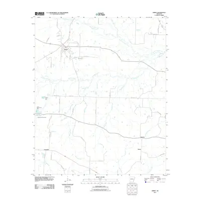
2011 Map of Emmet
USGS Topo · Published 2011About this map
Emmet serves as the primary hub in this portion of Nevada County, where a grid of local streets like Vine St and Hamilton Dr meets the regional transit routes. The landscape is defined by an intricate network of waterways, with Terre Rouge Creek and its tributary Little Terre Rouge Creek carving through the northern sections, while Whiteside Creek and Trammel Creek drain the south. These water sources historically influenced the positioning of local landmarks such as Snell Cemetery and the surrounding rural settlements. Evidence of local land management is found in several small reservoirs, including Rocky Mound Pond and Rolling Hills Pond, each identified by its own dam. Smaller communities such as Harmony, Sutton, and Centerville anchor the outlying agricultural areas, connected by a network of county roads including County Rd-14 and County Rd-31.
Find a feature on this map
50 named features on this map. Tap any name to fly to it.
Don’t see what you’re looking for? This feature index may not catch every label — zoom into the map to look around manually.
Map Details
Editions of this 2011 Emmet Map
This is the sole edition of this map. No revisions or reprints were ever made.
Other maps of this area

1901 · Gurdon
USGS Topo · 1:125,000

1951 · Blevins
USGS Topo · 1:24,000

1951 · Patmos
USGS Topo · 1:24,000

1951 · Hope
USGS Topo · 1:24,000

1953 · El Dorado
USGS Topo · 1:250,000

1957 · El Dorado
USGS Topo · 1:250,000

1958 · El Dorado
USGS Topo · 1:250,000

1960 · El Dorado
USGS Topo · 1:250,000

1970 · Prescott East
USGS Topo · 1:24,000
1970 · Prescott West
USGS Topo · 1:24,000