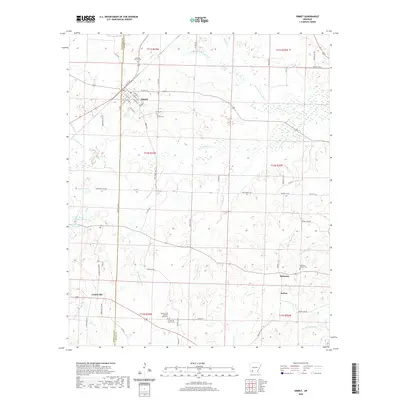
2020 Map of Emmet
USGS Topo · Published 2020About this map
Emmet sits at the intersection of local history and rural geography, straddling the line between Hempstead and Nevada counties. The settlement is defined by its grid of streets such as S Main St and S Walnut St, serving as a central hub for the surrounding agricultural and timbered landscape. The area is notable for its numerous burial grounds, including the Briant Cem African American and the Snell Cem, which provide significant points of interest for genealogists tracking local families.
Find a feature on this map
72 named features on this map. Tap any name to fly to it.
Don’t see what you’re looking for? This feature index may not catch every label — zoom into the map to look around manually.
Map Details
Editions of this 2020 Emmet Map
This is the sole edition of this map. No revisions or reprints were ever made.
Other maps of this area

1901 · Gurdon
USGS Topo · 1:125,000

1951 · Blevins
USGS Topo · 1:24,000

1951 · Patmos
USGS Topo · 1:24,000

1951 · Hope
USGS Topo · 1:24,000

1953 · El Dorado
USGS Topo · 1:250,000

1957 · El Dorado
USGS Topo · 1:250,000

1958 · El Dorado
USGS Topo · 1:250,000

1960 · El Dorado
USGS Topo · 1:250,000

1970 · Prescott East
USGS Topo · 1:24,000
1970 · Prescott West
USGS Topo · 1:24,000