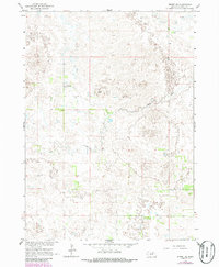
1964 Map of Emmet SE
USGS Topo · Published 1986About this map
The Missouri River Basin development program informed this mid-century topographic study of Holt County, Nebraska. This region of the state is characterized by the meandering path of Dry Creek, which cuts across the landscape among numerous depressions and intermittent water features typical of the local plains. The settlement of Schaffer sits along an unimproved road network, serving as a primary point of reference in an otherwise sparse agricultural landscape. Small-scale industrial activity is evidenced by a Claypit located in the southeastern quadrant, while the presence of a Flowing Well to the northwest highlights the importance of groundwater management for the area's residents and ranchers. Surveyed in the early 1960s with revisions in the mid-1980s, the map provides a precise look at the township and range divisions that defined land ownership during this era of rural Nebraska history.
Find a feature on this map
7 named features on this map. Tap any name to fly to it.
Don’t see what you’re looking for? This feature index may not catch every label — zoom into the map to look around manually.
Map Details
Editions of this 1964 Emmet SE Map
2 editions found
Other maps of this area

1955 · O'Neill
USGS Topo · 1:250,000

1958 · O'Neill
USGS Topo · 1:24,000

1959 · O'Neill
USGS Topo · 1:250,000

1964 · Emmet NW
USGS Topo · 1:24,000

1964 · Emmet SE
USGS Topo · 1:24,000

1964 · Emmet SW
USGS Topo · 1:24,000

1964 · O'Neill SW
USGS Topo · 1:24,000

1964 · Emmet
USGS Topo · 1:24,000

1969 · O'Neill
USGS Topo · 1:250,000

1981 · Amelia
USGS Topo · 1:24,000