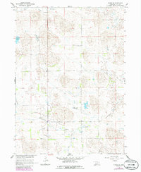
1964 Map of Emmet SW
USGS Topo · Published 1986About this map
The waters of Holt Creek and Dry Creek wind through this rural Nebraska landscape, defining a region where water management was central to life in the mid-1960s. The presence of several Flowing Wells indicates a reliance on the underlying aquifer to support livestock and agriculture in this corner of Holt County. Education in this sparsely populated area is anchored by School No 231, reflecting the localized school district system of the mid-20th century. Numerous small bodies of water, including Lizard Lake, West Lake, East Lake, and Gold Lake, are scattered across the terrain, suggesting a complex wetland or prairie pothole geography. This 1964 survey, which includes photorevisions from the mid-1980s, documents the persistence of these natural features and the basic infrastructure of a ranching or farming community before later land-use changes.
Find a feature on this map
10 named features on this map. Tap any name to fly to it.
Don’t see what you’re looking for? This feature index may not catch every label — zoom into the map to look around manually.
Map Details
Editions of this 1964 Emmet SW Map
2 editions found
Other maps of this area

1955 · O'Neill
USGS Topo · 1:250,000

1959 · O'Neill
USGS Topo · 1:250,000

1964 · Emmet NW
USGS Topo · 1:24,000

1964 · Emmet SE
USGS Topo · 1:24,000

1964 · Emmet SW
USGS Topo · 1:24,000

1964 · Emmet
USGS Topo · 1:24,000

1969 · O'Neill
USGS Topo · 1:250,000

1981 · Swan Lake
USGS Topo · 1:24,000

1981 · Amelia
USGS Topo · 1:24,000
1981 · Chambers West
USGS Topo · 1:24,000