
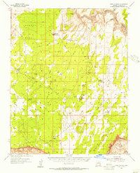
1954 Map of Emmett Wash NE
USGS Topo · Published 1955About this map
The Vermilion Cliffs and the Paria Plateau dominate this 1954 topographic survey, illustrating the dramatic geological transitions of the Arizona high desert. This preliminary edition captures a landscape defined by sharp elevation drops and arid drainage systems like Emmett Wash and Rock Wash, which eventually feed toward the Colorado River in the southeast. Human presence is sparse but concentrated along the route of Highway 89, where the Cliff Dwellers Lodge and a nearby Landing Strip served mid-century travelers and adventurers. Further south and west, isolated outposts such as Lowery, Kram Ranch, and a lone House indicate the remote ranching and residential sites that persisted in this challenging environment. The map provides a precise record of bench marks and vertical angles used by surveyors to navigate the complex verticality of the cliffs and plateaus before modern developments altered the region.
Find a feature on this map
25 named features on this map. Tap any name to fly to it.
Don’t see what you’re looking for? This feature index may not catch every label — zoom into the map to look around manually.
Map Details
Editions of this 1954 Emmett Wash NE Map
This is the sole edition of this map. No revisions or reprints were ever made.
Other maps of this area

1886 · Echo Cliffs
USGS Topo · 1:250,000

1891 · Echo Cliffs
USGS Topo · 1:250,000

1954 · Emmett Wash NW
USGS Topo · 1:24,000

1954 · Paria Plateau SE
USGS Topo · 1:24,000

1954 · Paria Plateau SW
USGS Topo · 1:24,000

1954 · Lees Ferry SW
USGS Topo · 1:24,000

1954 · Tanner Wash
USGS Topo · 1:62,500

1954 · Emmett Wash
USGS Topo · 1:62,500

1954 · Lees Ferry
USGS Topo · 1:62,500
1954 · Paria Plateau
USGS Topo · 1:62,500