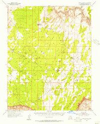
1954 Map of Paria Plateau
USGS Topo · Published 1956About this map
Paria Plateau dominates this high desert landscape, bounded to the south by the towering Vermilion Cliffs and to the east by the White Cliffs. In the mid-1950s, this area of Coconino County remained a sparsely populated rangeland, where a network of Jeep Trails connected isolated outposts like Jarvis Ranch and Joes Ranch. The presence of Pine Tree Pockets Well and various water tanks highlights the essential infrastructure required for cattle ranching in this arid environment.
Find a feature on this map
31 named features on this map. Tap any name to fly to it.
Don’t see what you’re looking for? This feature index may not catch every label — zoom into the map to look around manually.
Map Details
Editions of this 1954 Paria Plateau Map
4 editions found
Other maps of this area

1886 · Kanab
USGS Topo · 1:250,000

1886 · Escalante
USGS Topo · 1:250,000

1886 · Echo Cliffs
USGS Topo · 1:250,000

1886 · Kaibab
USGS Topo · 1:250,000

1891 · Echo Cliffs
USGS Topo · 1:250,000

1936 · Jacobs Lake
USGS Topo · 1:48,000

1940 · Jacob Lake
USGS Topo · 1:62,500

1953 · Jacobs Lake
USGS Topo · 1:62,500

1953 · Nipple Butte
USGS Topo · 1:62,500

1953 · Cedar City
USGS Topo · 1:250,000