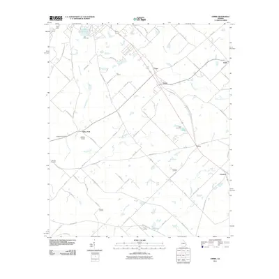
2011 Map of Empire
USGS Topo · Published 2011About this map
Empire and Dubois serve as central points in this rural landscape, which is characterized by a dense network of local roads and waterways. The geography is defined by numerous small water bodies, including Lake Linda and Lake Lissie, along with several tributaries such as Limestone Creek and Brushy Creek. The region's history is deeply connected to its burial grounds, with Friendship Cemetery, Simmons Cemetery, and Limestone Memorial Gardens providing valuable landmarks for genealogical research and local history. The settlement pattern follows established routes like the Joe Legg Rd and Chicken Rd, illustrating a community anchored by agricultural land and small crossroads like Roddy and Gresston. The presence of multiple pond dams, including the Livingston Pond Dam, indicates a managed landscape where water resources have been carefully developed for local use.
Find a feature on this map
74 named features on this map. Tap any name to fly to it.
Don’t see what you’re looking for? This feature index may not catch every label — zoom into the map to look around manually.
Map Details
Editions of this 2011 Empire Map
This is the sole edition of this map. No revisions or reprints were ever made.
Other maps of this area

1956 · Cochran
USGS Topo · 1:62,500

1957 · Macon
USGS Topo · 1:250,000

1958 · Macon
USGS Topo · 1:250,000

1964 · Macon
USGS Topo · 1:250,000

1972 · Eastman
USGS Topo · 1:24,000

1972 · Finleyson East
USGS Topo · 1:24,000

1972 · West Of Eastman
USGS Topo · 1:24,000
1973 · Hawkinsville
USGS Topo · 1:24,000

1974 · Chester
USGS Topo · 1:24,000
1974 · Yonkers
USGS Topo · 1:24,000