
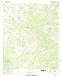
1972 Map of West Of Eastman
USGS Topo · Published 1975About this map
The Ocmulgee River curves through the southwestern corner of this territory, defining the boundary between Pulaski and Wilcox counties near Sandy Hammock. The interior landscape is dominated by the drainages of Mosquito Creek and its various branches, creating a network of ridges and lowlands that shaped the distribution of local farmsteads. In the early 1970s, this area remained deeply rural, characterized by a high density of country churches and small family cemeteries scattered along the secondary roads.
Find a feature on this map
33 named features on this map. Tap any name to fly to it.
Don’t see what you’re looking for? This feature index may not catch every label — zoom into the map to look around manually.
Map Details
Editions of this 1972 West Of Eastman Map
2 editions found
Other maps of this area

1956 · Cochran
USGS Topo · 1:62,500

1957 · Macon
USGS Topo · 1:250,000

1958 · Macon
USGS Topo · 1:250,000

1964 · Macon
USGS Topo · 1:250,000

1972 · Eastman
USGS Topo · 1:24,000

1972 · Finleyson East
USGS Topo · 1:24,000

1972 · Abbeville North
USGS Topo · 1:24,000

1972 · Pineview East
USGS Topo · 1:24,000

1972 · Lake Cypress
USGS Topo · 1:24,000
1973 · Hawkinsville
USGS Topo · 1:24,000