
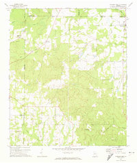
1972 Map of Finleyson East
USGS Topo · Published 1975About this map
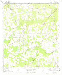
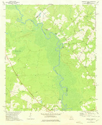
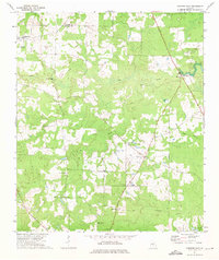
The Ocmulgee River meanders through this portion of Georgia, defining the landscape between Pulaski County and Wilcox County. This early 1970s survey documents a rural corridor centered on small settlements and religious centers such as Goose Neck and Finleyson. The distribution of community life is visible through numerous country churches like Piney Grove Ch and Sandridge Ch, alongside family-named burial grounds including Sapp Cem and Bohanon Cem. The terrain is shaped by an extensive network of waterways, with Big Creek and Limestone Creek flowing toward the river, and Blue Springs providing a distinct natural landmark. A long firebreak cuts through the timberlands east of the river, while the presence of a Boat Ramp at Treisch Lake highlights the river's role in local recreation and navigation during this era.
Find a feature on this map
31 named features on this map. Tap any name to fly to it.
Don’t see what you’re looking for? This feature index may not catch every label — zoom into the map to look around manually.
Map Details
Editions of this 1972 Finleyson East Map
This is the sole edition of this map. No revisions or reprints were ever made.
Other maps of this area
1956 · Cochran
USGS Topo · 1:62,500
1956 · Perry
USGS Topo · 1:62,500

1957 · Macon
USGS Topo · 1:250,000

1958 · Macon
USGS Topo · 1:250,000

1964 · Macon
USGS Topo · 1:250,000
1971 · Pineview West
USGS Topo · 1:24,000
1972 · West Of Eastman
USGS Topo · 1:24,000
1972 · Finleyson West
USGS Topo · 1:24,000
1972 · Abbeville North
USGS Topo · 1:24,000
1972 · Pineview East
USGS Topo · 1:24,000