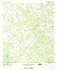
1972 Map of West of Eastman
USGS Topo · Published 1991About this map
A complex network of family cemeteries and rural congregations defines this Georgia landscape along the border of Pulaski, Dodge, and Wilcox counties. The terrain is shaped by the southern flow of the Ocmulgee River, which forms the southwestern boundary near the riverbank flats of Sandy Hammock. Inland, the topographic detail reveals a high concentration of local landmarks that suggest a deeply rooted agricultural community. Several small churches, including Zion Hill Ch, Salem Ch, and Harmony Ch, are situated along the ridgelines above the many tributaries. The area is heavily dissected by watercourses like Mosquito Creek and Hanley Branch, while long-established family names are preserved on the land through sites like Lancaster Cem, McAlister Cem, and Pittman Cem.
Find a feature on this map
32 named features on this map. Tap any name to fly to it.
Don’t see what you’re looking for? This feature index may not catch every label — zoom into the map to look around manually.
Map Details
Editions of this 1972 West of Eastman Map
2 editions found
Other maps of this area

1956 · Cochran
USGS Topo · 1:62,500

1957 · Macon
USGS Topo · 1:250,000

1958 · Macon
USGS Topo · 1:250,000

1964 · Macon
USGS Topo · 1:250,000

1972 · Eastman
USGS Topo · 1:24,000

1972 · Finleyson East
USGS Topo · 1:24,000

1972 · West Of Eastman
USGS Topo · 1:24,000

1972 · Abbeville North
USGS Topo · 1:24,000

1972 · Pineview East
USGS Topo · 1:24,000

1972 · Lake Cypress
USGS Topo · 1:24,000