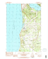
1983 Map of Empire
USGS Topo · Published 1984About this map
Empire stands as the central hub of this coastal survey, situated where the high bluffs of Sleeping Bear Dunes National Lakeshore meet the waters of Lake Michigan. The landscape is defined by the unique hydrology of the Leelanau Peninsula, where bodies of water like North Bar Lake and South Bar Lake are separated from the Great Lake by narrow strips of sand. To the north, the winding Pierce Stocking Scenic Drive navigates the elevation changes of Shauger Hill, while the Maple Grove Cem provides a point of genealogical interest for local families. The presence of the Radar Station and the Empire Airport 300 Runways suggests the village's strategic and logistical role during the late twentieth century, even as much of the surrounding terrain is preserved within the Pere Marquette State Forest.
Find a feature on this map
43 named features on this map. Tap any name to fly to it.
Don’t see what you’re looking for? This feature index may not catch every label — zoom into the map to look around manually.
Map Details
Editions of this 1983 Empire Map
2 editions found
Other maps of this area

1954 · Traverse City
USGS Topo · 1:250,000

1954 · Manitowoc
USGS Topo · 1:250,000

1956 · Thompsonville
USGS Topo · 1:62,500

1956 · Frankfort
USGS Topo · 1:62,500

1957 · Empire
USGS Topo · 1:62,500

1957 · Maple City
USGS Topo · 1:62,500

1958 · Traverse City
USGS Topo · 1:250,000

1958 · Manitowoc
USGS Topo · 1:250,000

1976 · Frankfort NW
USGS Topo · 1:24,000

1976 · Thompsonville NW
USGS Topo · 1:24,000