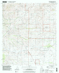
1996 Map of Empire Ranch
USGS Topo · Published 2002About this map
Empire Ranch serves as a focal point in this high-desert landscape of Pima County, positioned at the edge of the Las Cienegas National Conservation Area. The map reveals a transition from the drainage systems of Davidson Canyon and Empire Gulch to the rising elevations of the Santa Rita Mountains and Empire Mountains. The settlement pattern is defined by isolated outposts and livestock infrastructure, including High Haven Ranch, Hidden Valley Ranch, and the Oak Tree Windmill. Mining activity is evident through the Helena Mine and numerous drill holes scattered across the terrain. Historical local activity is further marked by the presence of Greaterville in the southwest and the Rosemont Camp area, connected by a network of 4WD trails and primitive roads that navigate the complex system of gulches like Los Posos Gulch and Ophir Gulch.
Find a feature on this map
53 named features on this map. Tap any name to fly to it.
Don’t see what you’re looking for? This feature index may not catch every label — zoom into the map to look around manually.
Map Details
Editions of this 1996 Empire Ranch Map
This is the sole edition of this map. No revisions or reprints were ever made.
Other maps of this area

1904 · Patagonia
USGS Topo · 1:125,000

1905 · Patagonia
USGS Topo · 1:125,000

1922 · Agus Caliente
USGS Topo · 1:62,500

1926 · Helvetia
USGS Topo · 1:62,500

1932 · Elgin
USGS Topo · 1:62,500

1940 · Elgin
USGS Topo · 1:62,500

1947 · Elgin
USGS Topo · 1:62,500

1948 · Elgin
USGS Topo · 1:24,000

1948 · Sonoita
USGS Topo · 1:24,000

1956 · Nogales
USGS Topo · 1:250,000