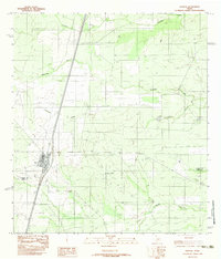
1982 Map of Encinal
USGS Topo · Published 1982About this map
Encinal serves as the primary hub of activity in this semi-arid landscape near the south Texas border, positioned along the major transportation corridor that divides the quadrangle. The town's grid is clustered west of the railway, while the surrounding brush country is defined by a series of intermittent drainages. Waterways such as Tecolote Creek, Jaboncillo Creek, and Chucareto Creek snake across the terrain, illustrating the importance of ephemeral water sources in this ranching region. The map also documents the transition into northern Webb County, marked by the La Salle Co Webb Co boundary and the smaller settlement of Las Comas. Industrial or infrastructure elements like a Radio Tower and Pump Station punctuate the landscape, reflecting the modern utility of this wide-open territory in the early 1980s.
Find a feature on this map
10 named features on this map. Tap any name to fly to it.
Don’t see what you’re looking for? This feature index may not catch every label — zoom into the map to look around manually.
Map Details
Editions of this 1982 Encinal Map
This is the sole edition of this map. No revisions or reprints were ever made.
Other maps of this area

1929 · Cotulla
USGS Topo · 1:125,000

1953 · Crystal City
USGS Topo · 1:250,000

1955 · Crystal City
USGS Topo · 1:250,000

1956 · Becerra
USGS Topo · 1:62,500

1956 · Webb
USGS Topo · 1:62,500

1956 · Laredo
USGS Topo · 1:250,000

1957 · Encinal
USGS Topo · 1:62,500

1957 · Caiman Creek
USGS Topo · 1:62,500

1961 · Crystal City
USGS Topo · 1:250,000

1968 · Crystal City
USGS Topo · 1:250,000