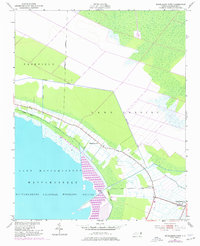
1951 Map of Engelhard West
USGS Topo · Published 1977About this map
Mattamuskeet National Wildlife Refuge dominates the landscape of eastern Hyde County, encompassing the vast waters of Lake Mattamuskeet and the surrounding marshlands. Based on 1950s surveys with mid-1970s revisions, this map captures the intricate drainage network of the Carolina coast, including the Jarvis Canal and the Boundary Canal. These man-made features define the agricultural boundaries of Fairfield and Lake Landing, where land reclaimed from the wetlands supports local farming. Along the settlement corridor leading toward the village of Engelhard, researchers will find localized landmarks like Pleasant Grove Ch and Fulford Cem. A Lookout Tower positioned near the refuge boundary provides a glimpse into the mid-century management of these protected coastal habitats and the rural life that borders them.
Find a feature on this map
13 named features on this map. Tap any name to fly to it.
Don’t see what you’re looking for? This feature index may not catch every label — zoom into the map to look around manually.
Map Details
Editions of this 1951 Engelhard West Map
4 editions found
Other maps of this area

1943 · Columbia
USGS Topo · 1:125,000

1943 · Roanoke Island
USGS Topo · 1:125,000

1951 · Middletown Anchorage
USGS Topo · 1:24,000

1951 · Middletown
USGS Topo · 1:24,000

1951 · Engelhard West
USGS Topo · 1:24,000

1951 · New Holland
USGS Topo · 1:24,000

1951 · Engelhard East
USGS Topo · 1:24,000

1951 · Fairfield
USGS Topo · 1:24,000

1953 · Engelhard NW
USGS Topo · 1:24,000

1953 · Fairfield NE
USGS Topo · 1:24,000