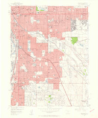
1957 Map of Englewood
USGS Topo · Published 1958About this map
The State Capitol and the bustling heart of Denver anchor the northwest of this mid-century landscape, where rapid postwar expansion begins to meet the residential enclaves of Englewood and Cherry Hills Village. This survey captures a significant moment of infrastructure growth, featuring the recently established Lowry Air Force Base and the expansive grounds of Stapleton Field Municipal Airport. The eastern edge is defined by the massive Cherry Creek Reservoir and the Cherry Creek Dam, engineering projects that would permanently alter the hydrology and development patterns of the area.
Find a feature on this map
135 named features on this map. Tap any name to fly to it.
Don’t see what you’re looking for? This feature index may not catch every label — zoom into the map to look around manually.
Map Details
Editions of this 1957 Englewood Map
This is the sole edition of this map. No revisions or reprints were ever made.
Other maps of this area

1890 · East Denver
USGS Topo · 1:125,000

1899 · West Denver
USGS Topo · 1:125,000

1935 · East Denver Nos. 3 and 4
USGS Topo · 1:48,000

1938 · Derby
USGS Topo · 1:24,000

1938 · Long Branch
USGS Topo · 1:24,000

1940 · Englewood
USGS Topo · 1:31,680

1940 · Derby
USGS Topo · 1:31,680

1941 · Long Branch
USGS Topo · 1:31,680

1941 · Fitzsimons
USGS Topo · 1:31,680

1941 · Arvada
USGS Topo · 1:31,680