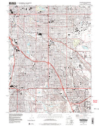
1997 Map of Englewood
USGS Topo · Published 1999About this map
Denver and its southern suburbs are shown here in the late twentieth century, revealing a landscape defined by dense residential growth and extensive public green spaces. The map details the prestigious campus of the University of Denver and the grounds of St Marys Academy, surrounded by neighborhood institutions like the Knight Sch and Cory Sch. This period captures the commercial peak of major regional hubs including the Cherry Creek Shopping Center and the sprawling Cinderella City Shopping Center near Englewood.
Find a feature on this map
109 named features on this map. Tap any name to fly to it.
Don’t see what you’re looking for? This feature index may not catch every label — zoom into the map to look around manually.
Map Details
Editions of this 1997 Englewood Map
This is the sole edition of this map. No revisions or reprints were ever made.
Other maps of this area

1890 · East Denver
USGS Topo · 1:125,000

1899 · West Denver
USGS Topo · 1:125,000

1935 · East Denver Nos. 3 and 4
USGS Topo · 1:48,000

1938 · Derby
USGS Topo · 1:24,000

1938 · Long Branch
USGS Topo · 1:24,000

1940 · Englewood
USGS Topo · 1:31,680

1940 · Derby
USGS Topo · 1:31,680

1941 · Long Branch
USGS Topo · 1:31,680

1941 · Fitzsimons
USGS Topo · 1:31,680

1941 · Arvada
USGS Topo · 1:31,680