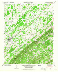
1944 Map of Englewood
USGS Topo · Published 1968About this map
Englewood serves as a focal point in the upper Tennessee Valley, situated along the Louisville and Nashville railroad line. The settlement pattern here reflects a classic Appalachian valley-and-ridge landscape, with the Monroe McMinn County Line following the crest of Chestuee Ridge. Local social centers are anchored by rural institutions like the Mt Arnon Sch and Rough Hill Ch, while the historical path of the Old Federal Road cuts across the drainage of Chestuee Creek. The map records a transition from the town center to the outlying knobs and gaps, such as Martin Gap and Kelly Knob, where small farms and cemeteries like Isbell Cem mark the family territories of the era. A dedicated County Farm and several remote schools like Estanelle Sch illustrate the self-contained nature of these mountain communities during the mid-1940s.
Find a feature on this map
63 named features on this map. Tap any name to fly to it.
Don’t see what you’re looking for? This feature index may not catch every label — zoom into the map to look around manually.
Map Details
Editions of this 1944 Englewood Map
4 editions found
Other maps of this area

1886 · Cleveland
USGS Topo · 1:125,000

1887 · Kingston
USGS Topo · 1:125,000

1891 · Kingston
USGS Topo · 1:125,000

1892 · Cleveland
USGS Topo · 1:125,000

1893 · Murphy
USGS Topo · 1:125,000

1893 · Kingston
USGS Topo · 1:125,000

1895 · Cleveland
USGS Topo · 1:125,000

1895 · Loudon
USGS Topo · 1:125,000

1901 · Cleveland
USGS Topo · 1:125,000

1914 · Murphy
USGS Topo · 1:125,000