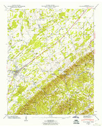
1944 Map of Englewood
USGS Topo · Published 1960About this map
Englewood and the older original settlement at Old Englewood anchor this 1944 survey of the McMinn and Monroe county border. The Louisville and Nashville railroad cuts a straight line through the valley, passing a Gaging Station and driving the development of the region's smaller stations and farming communities. Historical transportation routes are prominent, including the Old Federal Road and the Nashville and Cave Springs Road, which navigated the gaps between ridges like Rider Knob and Johnson Knob. Local life is recorded through a network of small churches and schools serving the rural populations near Nonaburg and Wilson Station. Genealogists will find many family-named cemeteries and landmarks, such as Cochran Cem and Isbell Cem, alongside several educational buildings like Caltharp Sch and Estanelle Sch.
Find a feature on this map
68 named features on this map. Tap any name to fly to it.
Don’t see what you’re looking for? This feature index may not catch every label — zoom into the map to look around manually.
Map Details
Editions of this 1944 Englewood Map
4 editions found
Other maps of this area

1886 · Cleveland
USGS Topo · 1:125,000

1887 · Kingston
USGS Topo · 1:125,000

1891 · Kingston
USGS Topo · 1:125,000

1892 · Cleveland
USGS Topo · 1:125,000

1893 · Murphy
USGS Topo · 1:125,000

1893 · Kingston
USGS Topo · 1:125,000

1895 · Cleveland
USGS Topo · 1:125,000

1895 · Loudon
USGS Topo · 1:125,000

1901 · Cleveland
USGS Topo · 1:125,000

1914 · Murphy
USGS Topo · 1:125,000