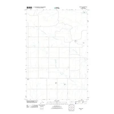
2011 Map of Enid SE
USGS Topo · Published 2011About this map
The high plains of Richland County are defined by the intricate drainage of Burns Creek and its many tributaries, including the Middle Fork Burns Creek. This landscape of dry-land agriculture and grazing is marked by essential water management features such as Senner Reservoir Dam, Fatzinger Dam, and the northern Wishbone Dam. The map reveals a dispersed rural community organized around a geometric grid of section roads like Road 508 and Road 510. Social and historical focal points are few but significant, including the Eastern Montana Bible Camp and the Bethlehem Mennonite Cemetery in the southwest, while the Klempel Cemetery sits further east. These sites, often located at the intersections of county routes like Road 523, indicate the enduring legacy of early homesteading and religious community life in this portion of eastern Montana.
Find a feature on this map
14 named features on this map. Tap any name to fly to it.
Don’t see what you’re looking for? This feature index may not catch every label — zoom into the map to look around manually.
Map Details
Editions of this 2011 Enid SE Map
This is the sole edition of this map. No revisions or reprints were ever made.
Other maps of this area

1909 · Glendive
USGS Topo · 1:250,000

1954 · Glendive
USGS Topo · 1:250,000

1957 · Glendive
USGS Topo · 1:250,000

1958 · Glendive
USGS Topo · 1:250,000
1966 · Intake NW
USGS Topo · 1:24,000
1972 · Red Top
USGS Topo · 1:24,000
1972 · Butler Table
USGS Topo · 1:24,000
1972 · Clay Butte
USGS Topo · 1:24,000
1972 · Fox Lake
USGS Topo · 1:24,000
1972 · Enid SE
USGS Topo · 1:24,000